I got a few rides in since the last post:
2011-01-12 (Wednesday) 10.2 miles
2011-01-13 (Thursday) 20 miles
2011-01-15 (Saturday) 25.5 miles
2011-01-16 (Sunday) 24.5 miles
2011-01-19 (Wednesday) 6 miles
2011-01-23 (Sunday) 30 miles
I decided to cut back a little this week since I am doing other exercises. I do Stair climbing Monday mornings now and Running on Fridays.
YTD miles: 272.6
Monday, January 24, 2011
Sunday, January 9, 2011
Another cold one...
Well I got in 40+ miles and I attempted to make another map but I left out one route through a subdivision in Lake Orion that would have lengthen the distance by maybe a quarter mile.
It was about 23 to 25 degrees out side.. I even stopped to take a photo of the "Enter Lapeer County" sign.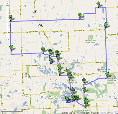
YTD total miles: 156.4
Google maps view.
It was about 23 to 25 degrees out side.. I even stopped to take a photo of the "Enter Lapeer County" sign.
YTD total miles: 156.4
Google maps view.
Saturday, January 8, 2011
Eight days in and 116.4 miles...
Wednesday (2011-01-05) I counted 3 of my 5 miles on the spinner.
Thursday (2011-01-06) I was able to get most of a complete lap in at Lake Orion H.S. Trail, about 7 miles.
Friday (2011-01-07) I did a repeat of Wednesday on the spinner and counted 3 miles.
Saturday (today) I did 26+ miles with Pauly...
YTD total miles: 116.4 miles.
Thursday (2011-01-06) I was able to get most of a complete lap in at Lake Orion H.S. Trail, about 7 miles.
Friday (2011-01-07) I did a repeat of Wednesday on the spinner and counted 3 miles.
Saturday (today) I did 26+ miles with Pauly...
YTD total miles: 116.4 miles.
Sunday, January 2, 2011
2 days and 2 rides into the new season.. 33.2 + 44.2 = 77.4 miles of hurt.
Pauly and I started off strong... we ended strong... The last 25% of the ride at the top of Fox Lake Rd. climb was interrupted with a support call.., my legs started to cool off but my feet and hands warmed up. We were off and stopped at Tim Hortons for a bagel and coffee... then sprinted home.
Today was 44.2 miles.
YTD total miles: 77.4
Today was 44.2 miles.
YTD total miles: 77.4
Saturday, January 1, 2011
2011... my first ride of the year.
 I did 33.1 miles in 2hrs and 15 minutes, which includes traffic lights and asking for directions at a Gas station.
The Google map
I was late getting to Clarkston for the Polar Ride... I was really bummed. The more I rode around not finding other bikers the more annoyed I got. So I decided to just start riding.. faster and faster... I got lost.. but at least I made it home.
| 1. | Head south on S Main St/Ortonville Rd toward Waldon Rd | 157 ft |
| 2. | Turn left at Waldon Rd | 0.2 mi |
| 3. | Turn right at Laurelton St | 138 ft |
| 4. | Slight left at Paramus | 0.2 mi |
| 5. | Turn right at Middle Lake Rd | 0.7 mi |
| 6. | Turn right at Pinehurst Ct | 0.3 mi |
| 7. | Turn left at Lakewood Blvd | 184 ft |
| 8. | Turn right at US-24 N/Dixie Hwy | 0.3 mi |
| 9. | Turn right at Lakeview Cemetery Bd/White Lake Rd Continue to follow White Lake Rd | 0.7 mi |
| 10. | Continue onto S Holcomb Rd | 2.8 mi |
| 11. | Continue straight onto Bridge Lake Rd | 2.2 mi |
| 12. | Turn left at Kier Rd | 0.7 mi |
| 13. | Head west on Kier Rd toward Gibbs Rd | 0.6 mi |
| 14. | Head west on Kier Rd toward Jossman Rd/Oakhill Rd | 180 ft |
| 15. | Continue straight onto Oakhill Rd | 0.9 mi |
| 16. | Turn right at Dixie Hwy | 0.1 mi |
| 17. | Turn right at Wildwood Rd | 0.7 mi |
| 18. | Head north on Wildwood Rd toward Top of Pines Dr/Top of the Pines | 2.3 mi |
| 19. | Head north on Wildwood Rd toward Grange Hall Rd | 269 ft |
| 20. | Turn right at Grange Hall Rd | 1.1 mi |
| 21. | Head east on Grange Hall Rd toward S Jossman Rd | 2.9 mi |
| 22. | Continue onto Mill St | 1.0 mi |
| 23. | Continue onto Hummer Lake Rd | 0.7 mi |
| 24. | Head east on Hummer Lake Rd W toward Woodland | 0.6 mi |
| 25. | Turn left to stay on Hummer Lake Rd W | 1.2 mi |
| 26. | Turn left to stay on Hummer Lake Rd W | 1.7 mi |
| 27. | Head east on Hummer Lake Rd W toward N Hurd Rd | 0.4 mi |
| 28. | Turn right at S Hurd Rd | 1.0 mi |
| 29. | Turn left at Granger Rd | 1.9 mi |
| 30. | Head east on Granger Rd toward N Coats Rd | 59 ft |
| 31. | Turn right at N Coats Rd | 2.1 mi |
| 32. | Turn left at W Drahner Rd | 0.7 mi |
| 33. | Head east on W Drahner Rd toward Dnr Access | 1.3 mi |
| 34. | Turn right at Polly Ann Trail - Oakland County | 1.5 mi |
| 35. | Turn left at Indianwood Rd | 0.3 mi |
| 36. | Turn right | 0.6 mi |
| 37. | Head south toward Marina Pointe Blvd | 187 ft |
| 38. | Continue straight onto Polly Ann Trail - Oakland County | 390 ft |
| 39. | Turn left toward Heights Rd | 0.6 mi |
| 40. | Turn left at Heights Rd | 0.6 mi |
| 41. | Turn left at Bellevue Ave | 0.1 mi |
| 42. | Turn left at W Bellevue Destination will be on the right | 138 ft |
Show on Google Maps
Subscribe to:
Comments (Atom)